


Research Project
PermaSAR: Development of a Method to Detect Subsidence by Means of D-InSAR in Permafrost Regions
News
Find all details in the final project report:
- Antonova, S., Beck, I., Marx, S., Anders, K., Boike, J., Höfle, B. (2019): Vorhabensbezeichnung: PermaSAR: Entwicklung einer Methode zur Detektion von Subsidenz in Permafrostgebieten mit D-InSAR: Schlussbericht: Laufzeit des Vorhabens: 01.04.2015-31.03.2019. Report No. 50EE1418, DOI: 10.2314/KXP:167848864X.
Data acquired in the PermaSAR study region is published on PANGAEA: TanDEM-X DEMs, ALS data, and Multitemporal ground-based data.
Project-related research can be followed on ResearchGate and news in our GIScience News Blog.
Objective
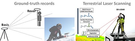
The project PermaSAR aims at developing a novel method for detecting vertical movements of the topography in a low Arctic permafrost region in Canada, based on:
- ground-truth records (using a differential GPS and subsidence stations)
- terrestrial laser scanning (TLS) to assess the microtopography and low tundra vegetation
- RADAR data (TanDEM-X) for differential interferometry (D-InSAR)
- optical remote sensed data for further analysis and evaluations.
Motivation
One quarter of the northern hemisphere is covered by permafrost and characterized by seasonal surface thawing (active layer). A warming of the permafrost temperatures has been observed for the last century in this region. Such warming provokes a deeper thawing layer during the summer months; this leads to severe consequences for the local population and the ecosystem. As these thawing and freezing processes of the permafrost are mainly responsible that streets break apart, buildings get cracks and potentially collapse, it is essential for science, economy and stakeholders (e.g. politics) to quantify these processes in order to identify potential subsidence areas (early warning system
) and to provide information to the local organization authorities to avoid severe damage.
The start of the TerraSAR-X/TanDEM-X satellites allows detecting fine-scale vertical surface movements by means of differential interferometry (D-InSAR). Previous studies showed the theoretical use of remote sensing data for such surface deformations, but also highlight limitations. The absolute values of vertical movements need improvement: Changing surface parameters (vegetation, microtopography and soil moisture) are also influencing the signal and masking the displacement information.
To overcome these limitations the aim of PermaSAR is to develop a multi-source methodology that improves the detection of vertical movements caused by thawing and freezing processes of the permafrost.
Publications
- Anders, K., Marx, S., Boike, J., Herfort, B., Wilcox, E.J., Langer, M., Marsh, P., Höfle, B. (2020): Multitemporal Terrestrial Laser Scanning Point Clouds for Thaw Subsidence Observation at Arctic Permafrost Monitoring Sites. Earth Surface Processes and Landforms, 45(7), pp. 1589-1600. DOI: 10.1002/esp.4833
- Antonova, S., Anders, K., Beck, I., Boike, J., Höfle, B., Marx, S. (2019): Digital Elevation Model from raw CoSSC TanDEM-X data (2015) in the area of Trail Valley Creek, Northwest Territories, Canada. PANGAEA, DOI: 10.1594/PANGAEA.902503.
- Antonova, S., Thiel, C., Höfle, B., Anders, K., Helm, V., Zwieback, S., Marx, S., Boike, J. (2019): Estimating tree height from TanDEM-X data at the northwestern Canadian treeline. Remote Sensing of Environment, 231, DOI: 10.1016/j.rse.2019.111251
- Höfle, B., Anders, K., Antonova, S., Boike, J., Marx, S. (2019): PermaSAR - Entwicklung einer Methode zur Detektion von Subsidence in Permafrostgebieten mit D-InSAR (in German). In: Zipf, A., Growe, A., Schmidt, S., Klonner, C.: Heidelberger Geographische Gesellschaft (HGG) Journal, 33, pp. 54-56.
- Anders, K., Antonova, S., Boike, J., Gehrmann, M., Hartmann, J., Helm, V., Höfle, B., Marsh, P., Marx, S., Sachs, T. (2018): Airborne Laser Scanning (ALS) Point Clouds of Trail Valley Creek, NWT, Canada (2016). Alfred Wegener Institute, Helmholtz Center for Polar and Marine Research, Bremerhaven, PANGAEA, DOI: 10.1594/PANGAEA.894884.
- Anders, K., Antonova, S., Beck, I., Boike, J., Höfle, B., Langer, M., Marsh, P., Marx, S. (2018): Multisensor ground-based measurements of the permafrost thaw subsidence in the Trail Valley Creek, NWT, Canada, 2015-2016. Alfred Wegener Institute, Helmholtz Center for Polar and Marine Research, Bremerhaven, PANGAEA, DOI: 10.1594/PANGAEA.888566.
- Marx, S., Anders, K., Antonova, S., Beck, I., Boike, J., Marsh, P., Langer, M. and Höfle, B. (2017): Terrestrial laser scanning for quantifying small-scale vertical movements of the ground surface in Arctic permafrost regions, ARCTIC CHANGE 2017 Conference, 12-15 December 2017. hdl: 10013/epic.373c192f-1178-4410-9825-0ebdb3753d6f.
- Antonova, S., Anders, K., Helm, V., Höfle, B., Marx, S. and Boike, J. (2017): Bistatic coherence from CoSSC TanDEM-X data for tree height estimation in the Canadian Subarctic, 5th HGF Alliance “Remote Sensing and Earth System Dynamics” Week, 26-30 June 2017. hdl: 10013/epic.51387.
- Marx, S., Anders, K., Antonova, S., Beck, I., Boike, J., Marsh, P., Langer, M., & Höfle, B. (2017): Terrestrial laser scanning for quantifying small-scale vertical movements of the ground surface in Arctic permafrost regions. Earth Surface Dynamics Discussions, 2017, pp. 1-31. DOI: 10.5194/esurf-2017-49.