3DGeo
3D Geospatial Data Processing Group
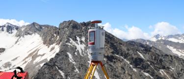
In the 3D Geospatial Data Processing (3DGeo) Group (Prof. Dr. Bernhard Höfle) we investigate and develop computational methods for the geographic analysis of 3D/4D point clouds.
Our datasets are acquired by cutting-edge Earth observation technology (e.g. laser scanning/LiDAR, photogrammetry/SfM and SAR). We aim at increasing the understanding of geographic phenomena by observing and analyzing them in full 3D, in near real-time with high spatial and temporal resolution.
Our methods can be applied to study physical processes (e.g. geomorphology), anthropogenic landscapes (e.g. emission reduction) and inherent human-environmental interactions (e.g. natural hazards, forestry and agriculture). Our research sites are spread all over the world: we perform in-situ 3D measurements, code in the lab and simulate Earth observation with our own open source software for virtual laser scanning.
Our latest news can also be found on our social media channels at ResearchGate, LinkedIn, Bluesky, Instagram and YouTube.
Quick start
Staff

Lorem ipsum dolor sit amet, consetetur sadipscing elitr, sed diam nonumy eirmod tempor invidunt ut labore et dolore magna aliquyam erat, sed diam voluptua. At vero eos et accusam et justo duo dolores et ea rebum. Stet clita kasd gubergren, no sea takimata sanctus est Lorem ipsum dolor sit amet.
Research

Lorem ipsum dolor sit amet, consetetur sadipscing elitr, sed diam nonumy eirmod tempor invidunt ut labore et dolore magna aliquyam erat, sed diam voluptua. At vero eos et accusam et justo duo dolores et ea rebum. Stet clita kasd gubergren, no sea takimata sanctus est Lorem ipsum dolor sit amet.
Publications

Our publications reflect our strong research focus on computational methods for 3D point cloud processing, change and time series analysis and LiDAR simulation, as well as our emphasis on open source software and open data.
Open Source Tools and Data
Lorem ipsum dolor sit amet, consetetur sadipscing elitr, sed diam nonumy eirmod tempor invidunt ut labore et dolore magna aliquyam erat, sed diam voluptua. At vero eos et accusam et justo duo dolores et ea rebum. Stet clita kasd gubergren, no sea takimata sanctus est Lorem ipsum dolor sit amet.
Teaching

Lorem ipsum dolor sit amet, consetetur sadipscing elitr, sed diam nonumy eirmod tempor invidunt ut labore et dolore magna aliquyam erat, sed diam voluptua. At vero eos et accusam et justo duo dolores et ea rebum. Stet clita kasd gubergren, no sea takimata sanctus est Lorem ipsum dolor sit amet.