| TrafU
Transformative Umweltforschung | Nicole Aeschbach,
Naomi Held | | | |
| 4D Objects-By-Change
Change Analysis of Natural Surfaces using 3D Time Series | Katharina Anders,
Bernhard Höfle,
Lukas Winiwarter | | | |
| M3C2-EP
Error propagation for topographic 3D change detection | Katharina Anders,
Bernhard Höfle,
Lukas Winiwarter | | | |
| Multi-Directional 3D topographic change | Katharina Anders,
Bernhard Höfle,
Veit Ulrich,
Jack G. Wiliams,
Lukas Winiwarter,
Vivien Zahs | | | |
| 3DForEcoTech
Three-dimensional forest ecosystem monitoring and better understanding by terrestrial-based technologies | | COST - European Cooperation in Science & Technology (seit 2021) | | |
| | Katharina Anders,
Bernhard Höfle,
Lukas Winiwarter | | | |
| Extract4D
Generalized Extraction of Surface Dynamics from Multimodal 4D Point Clouds for Topographic Monitoring of Earth Surface Processes and Their Interactions | | | | |
| Fostering a community-driven and sustainable HELIOS++ scientific software | Bernhard Höfle,
Hannah Weiser | | | |
| HELIOS++
Heidelberg LiDAR Operations Simulator | Bernhard Höfle,
Alberto Manuel Esmorís Pena (Catallactical S.L., ES),
Dominic Kempf (SSC),
Ronald Tabernig,
Hannah Weiser,
Lukas Winiwarter (University of Innsbruck, AT) | | | |
| Virtualearn3D
Virtual Laser Scanning for Machine Learning Algorithms in Geographic 3D Point Cloud Analysis | Bernhard Höfle,
Hannah Weiser | | | |
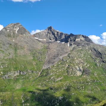
| AImon5.0
Real-time monitoring of gravitational mass movements for critical infrastructure risk management with AI-assisted 3D metrology | Bernhard Höfle,
William Albert,
Ronald Tabernig | | | |
| CharAct4D
Unravelling Landscape Dynamics via Automatic Characterization of Surface Activity using Geographic 4D Monitoring | Katharina Anders (TU Munich),
Bernhard Höfle,
Maria Federer (TU Munich),
Vivien Zahs | Baden-Württemberg Stiftung | | |
| E-TRAINEE
E-learning course on Time Series Analysis in Remote Sensing for Understanding Human-Environment Interactions | Bernhard Höfle,
Katharina Anders,
Sina Zumstein | Erasmus+ Programme of the European Union | | |
| AHK-4D
High-resolution and high-frequency monitoring of the rock glacier Äußeres Hochebenkar (AHK) in Austria | Bernhard Höfle,
Ronald Tabernig,
Hannah Weiser | | | |
| LOKI
Airborne Observation of Critical Infrastructures (Luftgestützte Observation Kritischer Infrastrukturen) | | | | |
| SYSSIFOSS
Synthetic structural remote sensing data for improved forest inventory models | Bernhard Höfle,
Nina Krašovec,
Hannah Weiser,
Lukas Winiwarter | | | |
| ER3DS
Emission Reduction in Smart Cities Using 3D Spatial Sensing and Analysis | Nicole Aeschbach,
Katharina Anders,
Bernhard Höfle,
Lukas Winiwarter,
Vivien Zahs | | | |
| Auto3Dscapes
Autonomous 3D Earth Observation of Dynamic Landscapes | Katharina Anders,
Bernhard Höfle,
Hubert Mara,
Thomas Scharffenberger | | | |
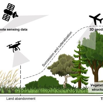
| Ruderalization and invasive species spread as a consequences of land abandonment in European landscapes after 1990: detection and assessment using remote sensing | Katharina Anders,
Bernhard Höfle,
Zhaleh Siabi | 4EU+European University Alliance | | |
| Towards sustainable development of natural environments based on continuous remote sensing monitoring | Bernhard Höfle,
Katharina Anders,
Lukas Winiwarter,
Vivien Zahs | 4EU+ European University Alliance | | |
| Farmland abandonment in Europe
Establishment of network for testing novel data sets and methods to monitor the patterns and evaluate its drivers | Katharina Anders,
Bernhard Höfle,
Sylvia Pscheidl | 4EU+European University Alliance | | |
| GEODYNAMO4D
Tracing geographic dynamics on 4D Point Clouds | Bernhard Höfle,
Lukas Winiwarter | | | |
| Geomorph4D
Characterising multi-process geomorphic change through high spatial- and high temporal-resolution monitoring | Bernhard Höfle,
Jack G. Williams,
Vivien Zahs | | | |
| HELIOS
Heidelberg LiDAR Operations Simulator | Bernhard Höfle,
Niko Lucač,
Jorge Martínez Sánchez,
Alberto Manuel Esmorís Pena,
Katharina Anders,
Lukas Winiwarter,
Hannah Weiser,
Mark Searle | | | |
| Landcover monitoring
with emphasis on vegetation under the climatic change pressure using multitemporal and multisource remote sensing data fusion | | 4EU+ European University Alliance | | |
| PermaSAR
Development of a Method to Detect Subsidence by Means of D-InSAR in Permafrost Regions News | Julia Boike,
Inga Beck,
Sabrina Marx,
Katharina Anders | | | |
| NEOHAZ: NEOgeography of a Digital Earth
Geoinformation Science as Methodological Bridge in Interdisciplinary Natural HAZard Analysis (NEOHAZ) | Michael Hölscher,
Carolin Klonner,
Sabrina Marx,
Tomás Usón | | | |
| 3D-TAIGER
Multi-Source 3D Geoinformation Extraction for Improved Management of Forest and Natural Hazards – Collaboration between TAIwan and GERmany | Ming-Chee Wu,
Chi-Kuei Wang,
Kristina König,
Martin Hämmerle | | | |
| 4DEMON
4D Near Real-Time Environmental Monitoring | Dirk Hoffmeister,
Martin Hämmerle,
Evelyn Schmitz | Ministry of Science, Research and Arts, Baden- Wuerttemberg | | |
| 3D-MAPP
3D-MicroMapping of Big 3D Geo-Datasets in the Web | Benjamin Herfort,
Florian Hillen,
Marcel Kaibel | | | |
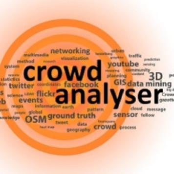
| PhD Graduate School: CrowdAnalyser
Spatio-temporal Analysis of User-generated Content | Alexander Zipf,
Michael Gertz,
Björn Ommer | Landesgraduiertenförderung Baden-Württemberg | | |
| LS-VISA
3D Laser Scanning – Vegetation Investigation and Signature Analysis | Kristina König,
Andreas Kiefer,
Luisa Griesbaum,
Zsófia Koma | | | |
| MUSIEKE
Multidimensional Perceptibility of Cultural Heritage | Christian Witschel,
Caroline Y. Robertson von Trotha,
Alexander Zipf,
Stefan Hinz,
Thomas Vögtle,
Hubert Mara,
Ralf Schneider | | | |
| Teaching Excellence Grant
3D GIScience Methods for Geographic Analysis | Bernhard Höfle | MWK-BW | 2014 |
| Landscape and Climate Change in the Last 2000 Years in the Altmühltal/Bavaria | Cooperation with Environmental Physics and Institute of Pre- and Early History | DFG | 2013–2014 |
| Climate Impact on Malnutrition
a Geospatial and Public Health Approach | Cooperation with Institute of Public Health | DFG | 2013–2014 |
| ESOB
Multi-sensor technology for the optimization of plant production ratings | Martin Hämmerle,
Sabrina Marx,
Larissa Müller,
Fabian Schütt | | | |
| BarSolPot
Nationwide cadaster for the solar potential of photovoltaic systems on noise and wildlife barriers | Sabrina Marx,
Sudhanshu Shekhar,
Andreas Reimer | | | |
| HedALS
Predictive Accuracy of Large-Scale Spatial Hedonic Price Models Using Laser | Marco Helbich,
Andreas Jochem | Alexander von Humboldt Foundation | 2011–2013 |
| Global Network
Airborne Laser Scanning for 3D Vegetation Characterization: Set-up of an International Signature Database | | | | |
| HyLand
Hyperspectral Remote Sensing for Precision Farming | Cooperation with University Osnabrück,
Technichal University Munich,
Julius-Kühn-Insitute Braunschweig | BMWi & DLR | 2010–2013 |