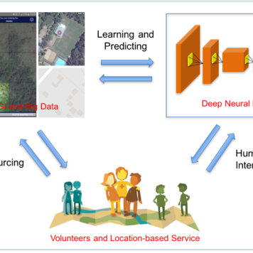
| Harnessing spatiotemporal crowdsourced data
Identify key spatial and behavioral factors that inform the design and delivery of targeted public health interventions as a framework for pandemic preparedness | Till Bärnighausen,
Claudia Denkinger,
Sven Lautenbach,
Alexander Zipf,
Ivonne Morales | | | |
| GeCO
Generating high-resolution CO2 maps by Machine Learning-based geodata fusion and atmospheric transport modelling | Alexander Zipf,
Sanam Vardag,
André Butz,
Sven Lautenbach (Geoinformatik) | | | |
| Climate Change and Health
Improving health care for vulnerable populations in Africa through spatially high-resolution monitoring of the natural and anthropogenic environment | Alexander Zipf,
Till Bärninghausen | Marsilius Kolleg (Exzellenzinitiative) | | |
| Harnessing Data Science for Global Health Priorities in Africa | GIScience Research Group,
HeiGIT gGmbH | | | |
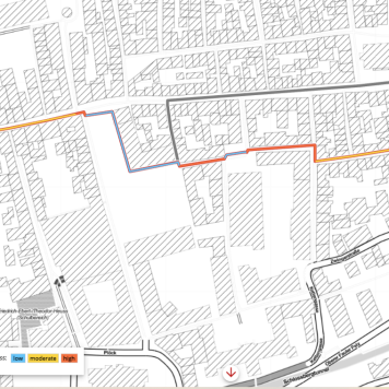
| HEAL
A safe way through the heat – Transdisciplinary project HEAL makes everyday life easier for at-risk groups | GIScience Research Group,
HeiGIT gGmbH | Baden-Württemberg Stiftung | | |
| GeoWiKI
Integrating Geographical Knowledge into Artificial Intelligence | GIScience Research Group,
HeiGIT gGmbH,
Vector Foundation | | | |
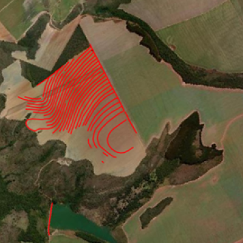
| geoEpi
spatio-temporal epidemiology of emerging viruses — leveraging crowdsourced data and occurrence data to improve early disease detection systems | Alexander Zipf,
Sven Lautenbach,
Steffen Knoblauch | | | |
| Project SocialMedia2Traffic
Derivation of traffic information from social media data | Alexander Zipf,
Johannes Fürle,
Christina Ludwig,
Mohammed Zia | | | |
| NACHWUCHS
Nachhaltiges AgriUrbanes ZusammenWachsen | | | | |
| HCE: Klimahandeln fundiert gestalten
Fallstudie Baden-Württemberg/Kalifornien | Tessio Novack,
D. Hauck,
Alexander Zipf | | | |
| IDEAL-VGI
Information Discovery from Big Earth Observation Data Archives by Learning from Volunteered Geographic Information | Alexander Zipf,
Sven Lautenbach,
Michael Schultz,
Moritz Schott | | | |
| meinGrün
Information and navigation on urban green spaces in cities | Alexander Zipf,
Sven Lautenbach,
Christina Ludwig,
Judith Levy,
Tessio Novack | Federal Ministery for Transport and Digital Infrastructure | | |
| | Alexander Zipf,
Carolin Klonner,
Mohammed Rizwan Khan | | | |
| DeepVGI
Deep Learning with Volunteered Geographic Information | | | | |
| | Robin Peters,
Tessio Novack,
Sven Lautenbach,
Alexander Zipf | | | |
| | | | | |
| OSM Landuse/Landcover Karte über Landnutzungsinformationen basierend auf OpenStreetMap | Alexander Zipf,
Michael Schultz | | | |
| OWS-6
OGC Web Services Phase 6 | | | | |
| | | | | |
| | | | | |
| Delhi Transit Routing Pilot Interoperability Initiative "DTRIP" | | | | |
| GDI-Grid
Geodateninfrastruktur-Grid | | | |
| FreeOpenLS.org | | | |
| OK-GIS
Offenes Katastrophenmanagement mit freiem GIS | | | |
| 3DGisMarkt.de | | | |
| Integration of Wind Simulation Models in 3D City Models | | | |
| Historic Information System for the Germany States 1815-1938 | | | |
| ImmoSDSS
A Web Spatial Decision Support System for the real estate market in RLP. | | | |
| Base Map Francfort Airport Online.
FRAPORT AG. | | | |
| GeoExchange.org
A geoportal for eXchanging Free geodata | | | |
| NOAH
International Flood Information and Warning System
(FLIWAS; Consultant) | | | |
| Advicer for EML within the BMBF project Advancement of Geoservices | | | |
| A web-based Flood Information System for the KABS
Kommunale Aktionsgemeinschaft zur Bekämpfung der Schnakenplage | | | |
| A web-based Economic Atlas for France
Co-Operation with SUPdeCO Montpellier, France | | | |
| MoNa3D
Mobile Navigation 3D | | | |
| SmartKom
BMBF-lead project on Human-Computer-Interaction Multi-Modal Mobile Assistance and Navigation System | | | |
| CRUMPET
„CReation of User-friendly Mobile services PErsonalized for Tourism“; (LBS) EU-Project; 5th. Framework; IST | | | |
| | | | | |
| TrafU
Transformative Umweltforschung | Nicole Aeschbach,
Naomi Held | | | |